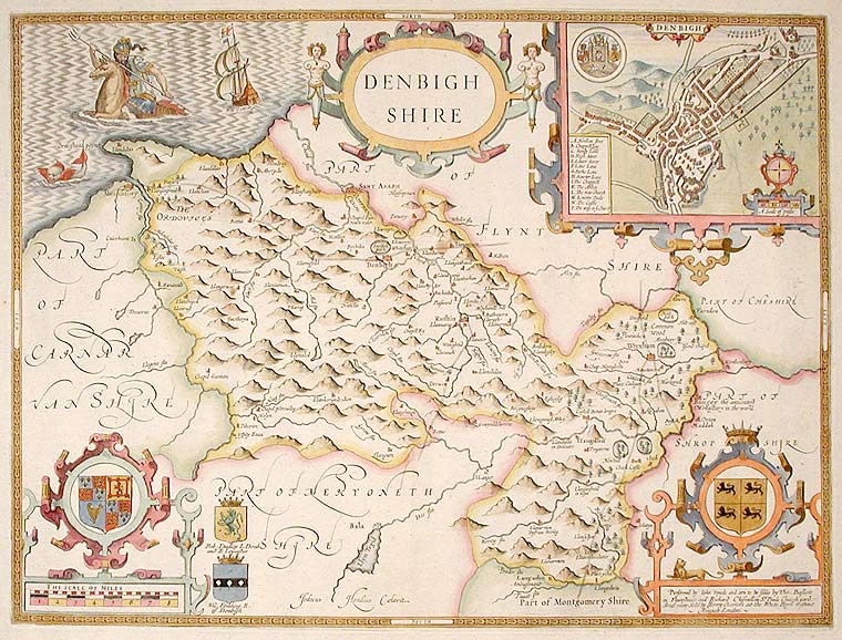

SPEED, John (c. 1552-1629)
Denbighshire
London: Henry Overton, Bassett & Chiswell, c. 1713. Copper-engraved map, with full modern colour, very large marings, in very good condition, except for a stain at the bottom edge, well away from the image. Sheet size: 22 x 26 inches.
A highly decorative map of Denbighshire by one of the greatest English cartographers
Denbighshire in Wales, clearly a mountainous region, was surveyed by Christopher Saxton, which was Speed's source for this map. William Smith, Pursuivant at the College of Arms, was the apparent source for the coats of arms: one of which is that of Robert Dudley, Earl of Leicester, Queen Elizabeth's favorite. In the town plan of Denbigh, in the upper right corner is a circular inset displaying what appears to be a castle. It is actually an unfinished and indeed never finished church that Leicester had tried to have built in Denbigh. Apparently, his unpopularity was part of the reason the church was never completed. The map is decorated with a sea monster, a classical god on horseback, and a ship. Henry Overton's edition of this map includes the few roads that snaked their way through the county.
cf. Hawkyard and Nicolson, The Counties of Britain A Tudor Atlas by John Speed, p. 73-76; Skelton, The County Atlases of the British Isles 1579-1850, Map Collector's Circle, part 1, #7 Speed and part 4, #92 & 121.
Item #12789
Price: $500.00