
DE L'ISLE, Guillaume and Covens & Mortier
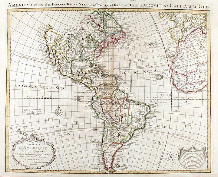
Carte D'Amerique Dressée pour l'Usage du Roy...1739. America Accurate in Imperia, Regna, Status & Populos Divisa, ad Usum Ludovici XV, Galliarum Regis
Amsterdam: Covens & Mortier, [1742]. Engraving with period outline colour. Some mild soiling. Discolouration at centerfold. Sheet size: 21 3/4 x 25 3/4 inches.
An elegant map of North and South America, the most accurate to date, produced for the "usage du Roy," Louis XV.
Guillaume de l'Isle (1675-1726) was the son of a cartographer and pupil of Jean Dominique Cassini, who, among other important contributions, aligned the study of astronomy to the study of geography. Under Cassini's direction, observations were made from locations all over the world that enabled longitudinal calculations to be made with much greater accuracy. De l'Isle carried on this exacting work with remarkable dedication and integrity, constantly revising and improving his maps. While precision was his primary goal, his maps are invariably elegant and attractive. Jean (Johannes) Covens and Corneille (Cornelius) Mortier were brothers-in-law, who carried on the book publishing business established by Pierre Mortier in Amsterdam in 1685. Pierre Mortier's company owed much of its success to his access to French publishers, whose publications he re-issued in handsome editions.The elder Mortier died in 1711; his wife continued the firm until she died in 1719. In 1721, Covens and Mortier formed a partnership, Covens having married Agatha Mortier in the same year. They continued the business by publishing enlarged editions of Sanson, Jaillot, and De L'Isle, as well as some of the later Dutch cartographical masters such as De Wit and Allard, and of course Pierre Mortier. This map is from an edition of De L'Isle entitled, Atlas Nouveau, Contenant Toutes Les Parties Du Monde, Ou sont exactement Remarquées les Empires, Monarchies, Royaumes, Etats, Republiques &c. Par Guillaume de l'Isle. Premier Géographe de sa Majesté. It is his map of North and South America shown on a large enough scale that western Europe and Africa are included. The map includes the rectification of South America's eastern coast line, correcting a map of South America whose Chilean-Argentinian peninsula swung to the west. The map also includes a Prime Meridian declared by Louis XIII, but not adopted and Pope Alexander VI's Line of Demarcation that divided the world (outside of Europe) between Portugal and Spain. Finally, it should be noted that De l'Isle resisted the temptation to depict California as an island, which was being done by many mapmakers of the period.
Koeman, C&M 7, #98.
Item #15052
Price: $800.00