
WHITE, John (fl. 1585-1593)
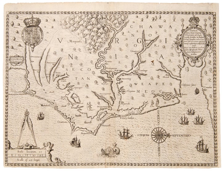
Americae pars, nunc Virginia dicta
Frankfurt: 1590. Copper-engraved map. Sheet size: 12 7/8 x 16 5/8 inches.
A seminal map of America: the first detailed depiction of the Virginia coast and Carolina capes, showing the coast from the mouth of the Chesapeake to Wilmington, North Carolina.
Theodore de Bry's map of Virginia, after John White, is one of the most significant cartographical milestones in colonial North American history. It was the most accurate map drawn in the sixteenth century of any part of that continent. It became the prototype of the area long after James Moxon's map in 1671. The region of Chesapeake Bay was, however, improved by the surveying of John Smiths around 1607. This is the first map to focus on Virginia (now largely North Carolina), and records the first English attempts at colonisation in the New World. Burden states: "The map concerned depicts the area from Chesapeake Bay to Cape Lookout. It exhibits greater knowledge than on any of the surviving manuscripts. Possibly this is from knowledge gained during White's brief visit in 1587 and signifies some lost manuscripts. Here we find the first printed use of the name Chesapeake, Chesepiooc Sinus, and the second of Roanoke (the first being Mazza). It depicts the positions of the Indian villages in the area and is adorned with the Royal Arms of England. The Latter's ships are shown at sea with Indian canoes traversing the inland waters. The two native scenes shown are taken from illustrations in the book. It influenced many maps, most notably those of de Jode 1593, Wytfliet 1597 and Metellus 1598. There are three states of the map, this is the second one with a 'C' superimposed on the first letter of the village called Ehesepiooc." Cumming comments: "Although this map lacks the authenticity of White's manuscript map of approximately the same area, the addition of some names and an improvement in coastal delineation may show increased knowledge gaines in 1587-88, after the manuscript map was made. De Bry's engraving of White's watercolor map is one of the most important type maps in Carolina cartography." Stephenson & McKee state: "The new geographical information imparted by the White-de Bry engraving swept through Europe and was incorporated into maps by other publishers for at least eighty years. Roanoke Island, neighboring Indian villages, and other features are identified. In addition, the entrance to the Chesapeake Bay, Chesepiooc Sinus, is named for the first time on a published map. De Bry oriented White's map to show west at the top rather than north. This became the preferred orientation for published maps of Virginia and other eastern seaboard colonies until the eighteenth century."
Burden 76; Cumming 12; Stephenson & McKee p.26 I-2.
Item #19424
Price: $23,000.00