
THORNTON, John (1641-1708) & Samuel (fl.1703-39)
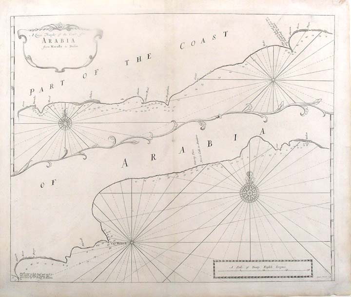
A Large Draught of the Coast of Arabia from Maculla to Dofar
London: William Mount & Thomas Page, [1734]. Copper-engraved sea chart by Sutton Nichols, in excellent condition apart from a small expert repair to the lower right and left corners. Sheet size: 19 x 22 3/4 inches.
A very fine sea chart of the coast of Yemen and Oman from the celebrated Third Book of 'The English Pilot'
This very attractive sea chart depicts the coast of the Arabian Peninsula from Al Makullah in Yemen to Dhofar in Oman. The coastal view is bisected into two images, separated by a border formed by the elegant tendrils of a vine. The upper view depicts the southern, while the lower portrays the northern aspect of the coast. Prominent features of the desert coastline are depicted, while compass roses, from which radiate rhumb lines, decorate the seas. In 1671, the London cartographer John Seller (fl.1664-97) commenced work on The English Pilot, a work that intended to challenge Dutch hegemony in the sea atlas market. Intended to be published in four books covering different regions of the globe, Seller published an uncompleted book on 'Oriental navigation' in 1675. Unable to continue this Herculean endeavour, Seller sold his rights to John Thornton, the official hydrographer to the English East India Company. Thornton took up the project with great fervour, publishing his first editions in 1689. Thornton did not publish his first edition of the Third Book, detailing navigation in the East Indies, until 1703. While Thornton largely based his charts on those of earlier Dutch cartographers, most notably those found in Pieter Goos' Zee-Spiegel and Lucas Janz Waghenaer's Mariner's Mirror, The English Pilot proved to be enormously popular. When John Thornton died in 1708, his brother Samuel took over the business and added to and modified existing charts. All four books were produced in editions until the 1760s, the Third Book ran into twelve editions up to 1761. The project succeeded in giving the English dominance in the sea chart market as the eighteenth-century progressed.
Tibbetts, Arabia in Early Maps, 177; Cf. Phillips, Atlases, 4278-18; Verner & Skelton (eds.), John Thornton - The English Pilot: The Third Book (Facsimile 1703 edition).
Item #19527
Price: $750.00