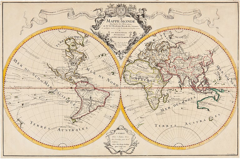
DE L'ISLE, Guillaume (1675-1726)
Mappe-Monde Drésse sur les Observations de Mrs. de l'Academie Royal des Sciences et quelques autres sur les memoires les plus recens
Paris: Chez l'Auteur Rue des Canettes pres de St. Sulpice, 1700. Copper-engraved map, hand-coloured in outline. Good condition, cut to just within the plate mark, with expert repairs to margins and central fold. Sheet size: 17 1/8 x 26 1/8 inches.
The rare first state of the celebrated world map by De l'Isle "one of the foremost cartographers of the age" (Shirley).
This highly important map proved to be one of the most influential world maps of its time, and is present here in the rare first state. De L'Isle was a much esteemed figure who, after being tutored by the great Jean-Dominique Cassini, became the geographer to the French Academy of Sciences in 1702, and then 'Premier Géographe' to Louis XV in 1718. Rodney Shirley notes that "De L'Isle's work is distinguished by its scientific basis, the minute care taken in all departments, constant revision, and personal integrity". In this map of the world, De l'Isle was among the first cartographers to re-establish California's true form as a peninsula, to give more or less accurate configurations to all five Great Lakes, and to show the full extent of the Mississippi. He was also one of the first to correct the attenuated form of the Mediterranean Sea. In fusing New Guinea and Australia, he followed William Dampier's presumed personal survey, but resisted the temptation to join Tasmania and New Zealand to Australia, an error soon to be popular. Curiously, the tip of South America is shown to curve sharply into the Pacific, a detail conspicuously amended in subsequent states of the map. The map also features the tracks of important circumnavigators including Magellan, Mendaña, Dampier, Van Noort, Le Maire & Schouten and the antipodean tracks of Abel Tasman.
ShirleyThe Mapping of the World: Early Printed World Maps 1472-1700, 603, plate 416; Wagner Cartography of the Pacific Northwest, 461.
Item #19711
Price: $1,250.00