
DES BARRES, J.F.W. (1721-1824)
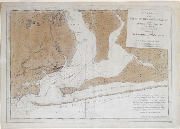
A chart of the bay and harbour of Pensacola in the province of West Florida surveyed by George Gauld A.M.
London: J.F.W. Des Barres in the 'Atlantic Neptune', August 1st 1780. Engraved with aquatint, period (oxidized) color. Good condition apart from expert restoration to center fold, upper and lower margins. Sheet size: 22 3/16 x 31 5 1/6 inches.
A very rare and highly important sea chart of Pensacola Harbor from the 'Atlantic Neptune', the finest marine atlas of North America's east coast, produced during the Revolutionary War.
This superbly drafted map features the magnificent natural harbor of Pensacola on the Florida panhandle. The town, with its fort and carefully laid out streets is featured in the left-centre of the map. Another settlement "Campbell Town" is located further up the harbour toward where the entrance of the "Scambia" (Escambia) River. The borders of various land grants are demarcated, and the countryside is elegantly detailed with aquatint features, and coloured in a light brown-green wash. The chart precisely captures the features of the coast, showing how the harbor is protected by two sandy bars of land, the outer being Santa Rosa Island. The chart features a great deal of quantitative hydrographic information, and instructions to mariners are written in the lower right of the map, ensuring that it was by far the most accurate and comprehensive pilot for the harbor produced in the eighteenth-century. The present example is the first of two variants of this chart. It is important to note that the year this map was printed the region was caught up in the dramatic action of the Revolutionary War. The Spaniards, who had just joined the war on the American side, seized the British garrison at Fort Barrancas, and West Florida remained in their possession for the duration of the war. Joseph Frederick Wallet Des Barres was born in Switzerland, where his Huguenot ancestors had fled following the repeal of the Edict of Nantes. He studied under the great mathematician Daniel Bernoulli at the University of Basel, before immigrating to Britain where he trained at the Royal Military College, Woolwich. Upon the outbreak of hostilities with France in 1756, he joined the British Royal American Regiment as a military engineer. He came to the attention of General James Wolfe, who appointed him to join his personal detail. During this period he also worked with the legendary future explorer James Cook on a monumental chart of the St. Lawrence River. Upon the conclusion of the Seven Years War, Britain's empire in North America was greatly expanded, and this required the creation of a master atlas featuring new and accurate sea charts for use by the Royal Navy. Des Barres was enlisted to survey the coastlines of Nova Scotia, Newfoundland, and the Gulf of St. Lawrence. With these extremely accurate surveys in hand, Des Barres returned to London in 1774, where the Royal Navy charged him with the Herculean task of producing the atlas. Gradually he was forwarded the manuscripts of numerous advanced surveys conducted by British cartographers in the American Colonies, Jamaica and Cuba. The result was The Atlantic Neptune, which became the most celebrated sea atlas of its era, containing the first systematic survey of the east coast of North America. Des Barres's synergy of great empirical accuracy with the peerless artistic virtue of his aquatint views, created a work that "has been described as the most splendid collection of charts, plates and views ever published" (National Maritime Museum Catalogue). The Neptune eventually consisted of four volumes and Des Barres's dedication to the project was so strong that often at his own expense he continually updated and added new charts and views to various editions up until 1784, producing over 250 charts and views, many appearing in several variations. All of these charts were immensely detailed, featuring both hydrographical and topographical information, such that in many cases they remained the most authoritative maps of the regions covered for several decades. Following the completion of the Neptune, Des Barres returned to Canada, where he remained for forty years, becoming a senior political figure and a wealthy land owner, living to the advanced age of 103.
National Maritime Museum, Henry Newton Stevens Collection HNS 173A & Catalogue III, 144, p.384; Sellers & Van Ee, Maps and Charts of North America and the West Indies, 1663.
Item #19770
Price: $22,500.00