
MOLL, Herman (1654-1732)
A New and Correct Map of the World, Laid Down According to the Newest Discoveries, and From the Most Exact Observations
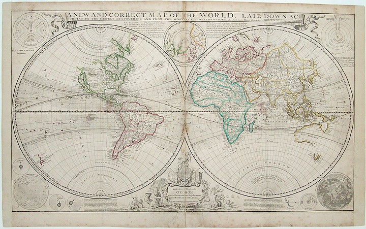
London: H. Moll, D. Midwinter, T. Bowles, P. Overton, [dated 1719, but circa 1730]. Copper-engraved map, on four joined sheets, with original outline colour. Marginal foxing, re-margined left and right margins, reinforced center fold, repaired tear bottom margin, toning at center fold. Sheet size: 25 x 40 1/2 inches.
A magnificent and monumental World map, showing the globe in the early days of the Age of Enlightenment and European imperialism.
This fascinating global perspective, featured in double-hemispheres, depicts the latest state of knowledge of the world in the first quarter of the eighteenth-century. The delineation of Europe, South America, and southern Asia is quite sophisticated, while the depiction of regions further beyond suggests only fleeting exploration or outright speculation. Most of the Arctic is labelled "Parts Unknown," and the American West is largely conjectural, featuring California as an island, the most beloved of cartographic misconceptions. Lands depicted to the east of the Spice Islands are scarcely contemplated, "Iesso," or Hokkaido, is shown to be part of Siberia, and eastern Australia is left as a complete enigma, decades before the voyages of James Cook. This map was intended to satiate the intense English interest in maritime exploration and commerce. The oceans within the Tropics of Cancer and Capricorn feature highly detailed hydrological information, most notably the direction of the ocean currents, that Moll gleaned from his esteemed contemporary Sir Edmond Halley. Evincing the scientific curiosity of the Enlightenment, each corner of the map features very detailed and elegant astronomical diagrams, including; the planetary systems according to both Ptolemy (geo-centric) and Copernicus (helio-centric) (with the addition of the path of a comet), the appearance of the Sun according to the Jesuit intellectual Athanasius Kircher; and the Appearance of the Moon according to Jean-Dominique Cassini. The five known planets are depicted as well, Saturn with its ring and Jupiter with four moons. The magnificent title cartouche, dedicated to George I, features classical sea gods, prefiguring the power of the Royal Navy that would allow the British to build a global empire later in the century. The present map was part of Herman Moll's magnificent folio work, a New and Compleat Atlas. Moll was the most important cartographer working in London during his era, a career that spanned over fifty years. His origins have been a source of great scholarly debate; however, the prevailing opinion suggests that he hailed from the Hanseatic port city of Bremen, Germany. Joining a number of his countrymen, he fled the turmoil of the Scanian Wars for London, and in 1678 is first recorded as working there as an engraver for Moses Pitt on the production of the English Atlas. It was not long before Moll found himself as a charter member of London's most interesting social circle, which congregated at Jonathan's Coffee House at Number 20 Exchange Alley, Cornhill. It was at this establishment that speculators met to trade equities (most notoriously South Sea Company shares). Moll's coffeehouse circle included the scientist Robert Hooke, the archaeologist William Stuckley, the authors Jonathan Swift and Daniel Defoe, and the intellectually-gifted pirates William Dampier, Woodes Rogers and William Hacke. From these friends, Moll gained a great deal of privileged information that was later conveyed in his cartographic works, some appearing in the works of these same figures. Moll was highly astute, both politically and commercially, and he was consistently able to craft maps and atlases that appealed to the particular fancy of wealthy individual patrons, as well as the popular trends of the day. In many cases, his works are amongst the very finest maps of their subjects ever created with toponymy in the English language.
Shirley, Maps in the Atlases of the British Library I, T.Moll-4b, 2; Cf. Reinhartz, The Cartographer and the Literati: Herman Moll and his Intellectual Circle.
Item #21290
Price: $5,400.00