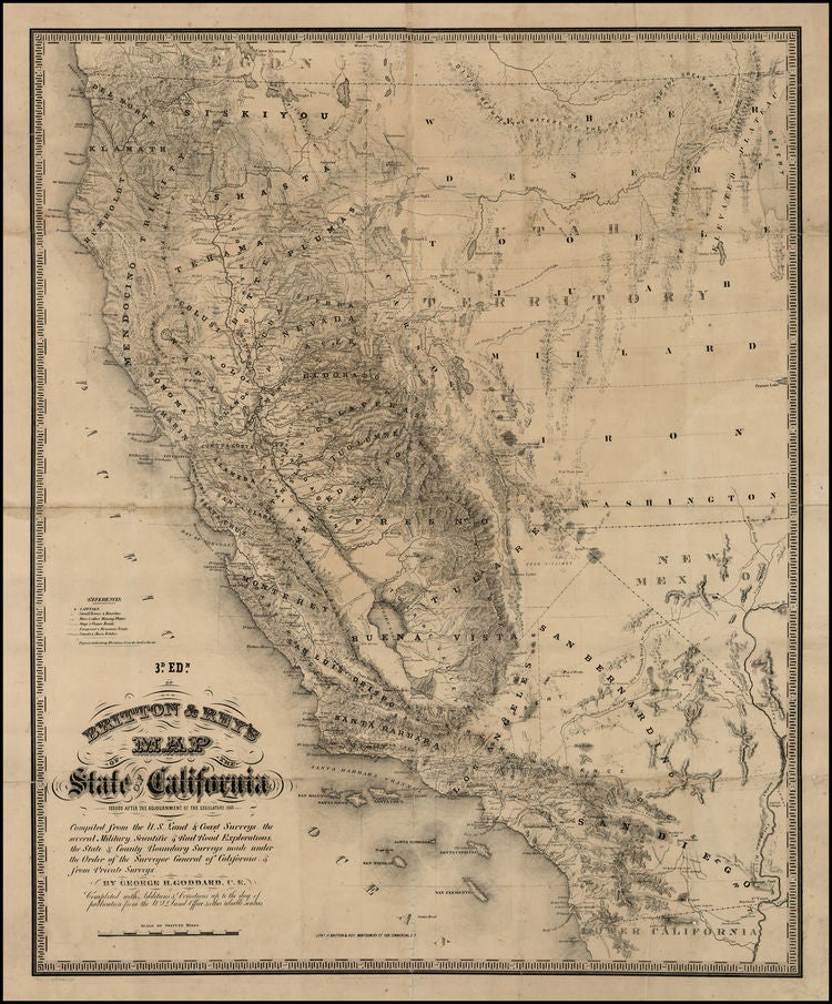

GODDARD, George
Britton & Rey's Map of the State of California
San Francisco: Lithographed by Britton & Rey, 1860. Lithographed map. Linen-backed. Sheet size: 30 1/4 x 24 3/4 inches.
Extremely rare map of California.
George H. Goddard came to California in 1850. In 1855, he surveyed a part of the boundary between California and Utah Territory (now Nevada). He later surveyed for the Western Pacific Railroad and for John Charles Fremont. He also surveyed most of the important passes Sierra Nevada Mountains. Mount Goddard still bears the name of this important early surveyor. In 1855, Goddard compiled a manuscript map of California on a scale of two miles to the inch. The map was a remarkable improvement on the best available maps, so much so that Marlette, the State Surveyor General petitioned the California legislature to purchase Goddard's map, stating that nowhere else could so complete and extensive a map be obtained. After the legislature rejected the proposal, Goddard submitted a version of the manuscript to Britton & Rey, who lithographed and published it for the first time in 1857. Among its many distinctions, it was the first map to accurately locate Lake Tahoe (here Lake Bigler), derived from Goddard's own surveys in the Sierra Nevada. The map shows towns and settlements, trails, wagon roads, and county boundaries. Relief is indicated by hachures; numerous spot elevations are given; and physical features are named. The scale is 1 inch to 24 miles. Coverage includes the western half of Utah Territory and a northwestern corner of New Mexico Territory--- the area comprising the future State of Nevada. The wealth of information which now appears throughout California in the present 1860 edition (stated on the map as the third edition) graphically discloses the extent to which large portions of this vast and hitherto empty land had been peopled. Gold had swiftly done its work. The Goddard map is a fitting monument to the frenzied activity and achievements of the gold seekers, and with it the purely Gold Rush phase of California cartography comes to an end. No example of either the 1858 second edition or the 1860 third edition have apparently been offered on the market in the past half century; only the Thomas W. Streeter copy of the 1857 first edition has appeared on the market in that time period. An exceptionally rare and important California map.
Gold Region, 302; Wheat, Transmississippi, 921; Heckrotte, California 49, 36; Streeter Sale, 2819; Phillips, America, p. 185.
Item #24045
Price: $12,000.00