
SANSON, Nicholas and Guillaume SANSON (d. 1703)
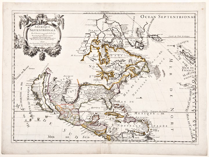
Amerique Septentrionale
Paris: Chez Pierre Mariette, 1690. Copper-engraved map, period hand colouring in outline. Sheet size: 17 7/8 x 24 inches.
Among the most important French maps of North America of the second half of the 17th century, produced by the country's most esteemed family of cartographers.
This very influential map was the official successor to Nicolas Sanson's 1650 map of North America. When Nicolas Sanson, regarded as the father of the renaissance of cartography under Louis XIV, died in July, 1667, he left his flourishing business under the charge of his eldest son Guillaume. The younger Sanson continued his father's partnership with the Mariette family, who were prominent Parisian printers. Guillame was determined to publish a new, updated edition of his father's Cartes Generales de toutes parties du Monde, the first French general atlas, originally published in 1657. The map of North America that appeared in the atlas, although masterful, was now considered to be geographically outdated. The present map, which appeared in the second edition of the atlas, featured updated toponymy, and is geographically based on Nicolas Sanson's wall map of 1666 (of which only two copies survive). While California is shown to be an island, in line with popular perception, unlike the map from 1650, it no longer attempts to build a geographical mythology in the place of the Pacific Northwest, which was then totally unknown. Appropriately the magnificent baroque title cartouche, which features swags and ribbons held aloft by putti, has been placed to fill this enigmatic space. Cartographically the map appears to be based on Sanson's maps of "Le Canada, ou Nouvelle France" and "Le Nouveau Mexique, et La Floride." Lake Erie is shown in a recognizable form and the entire Great Lakes network is shown in greater detail than his father's map, although the western lakes are still open-ended. On the East coast, Long Island is shown and the shape of the Outer Banks is improved. Several Indian tribes are identified in New Mexico where the R. del Norte (Rio Grande) mistakenly flows from an interior lake and empties into the Mar Vermeio ou Mer Rouge (Gulf of California). Iceland now appears in the Atlantic, as well as a bit of Britain. The map proved to be highly successful, and was sourced on numerous occasions by other mapmakers. The present copy is an example of Burden's second state of the map, with the date changed to 1690 in the cartouche and with additional place names and other changes: "...with minor alterations Terre de Jesso and Conibas inserted but without a coastline. Detroit d'Anian placed immediately above California and a few changes in spelling ... New Albion is inserted in the north of the island, and New York replaces [New] Amsterdam" (Tooley).
Burden, The Mapping of North America 404 (second state); McCorkle, New England in Early Printed Maps 669.4; cf. McLaughlin, California as an Island, 45; cf. Wagner, Cartography of the Northwest Coast of America, 399; Tooley, "California as an Island," 9 in Tooley,The Mapping of America.
Item #25648
Price: $2,800.00