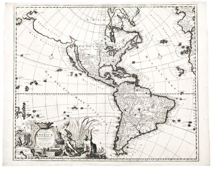

ALLARD, Carol (1648-1709)
Recentissima Novi Orbis, Sive Americae Septentrionalis et Meridionalis Tabula
Amsterdam: circa 1697. Copper-engraved map. Small inset of New Zealand within the cartouche. Sheet size: 20 1/2 x 25 1/2 inches.
Rare issue of Allard's map of North and South America, the first to show important corrections to the mapping of the Great Lakes and the Mississippi River Valley.
"The map of America by Allard is derived from that of Frederick de Wit, c. 1675" (Burden). Significantly, however, Allard corrects the mapping of the Great Lakes and Mississippi Valley. "The former are entirely re-engraved as are the nearby waterways off the St. Lawrence River including Lake Champlain, which is moved south-west. Lake Superior is now enclosed to the west as is Lac des Puans, which is renamed Lac Illinois, placing the previous toponym correctly in Green Bay. To the west an entirely new and more recent depiction of the Mississippi valley is inserted. This is derived from that of Louis Hennepin ... published in 1697" (Burden). This is Burden's second state, with a ruled border surrounding the New Zealand inset but without the textual descriptions of climates between the neat line and gradients. It is the first state to show the important corrections noted above. Beyond the cartographic importance, the cartouche is especially attractive, with an allegorical figure of America seated within a sugar cane field inhabited by exotic animals and scenes relating to mankind's eternal search for gold.
Burden, The Mapping of North America II: 724; McLaughlin, The Mapping of California as an Island, 132; Tooley, "California as an Island," in The Mapping of America 65.
Item #25649
Price: $1,500.00