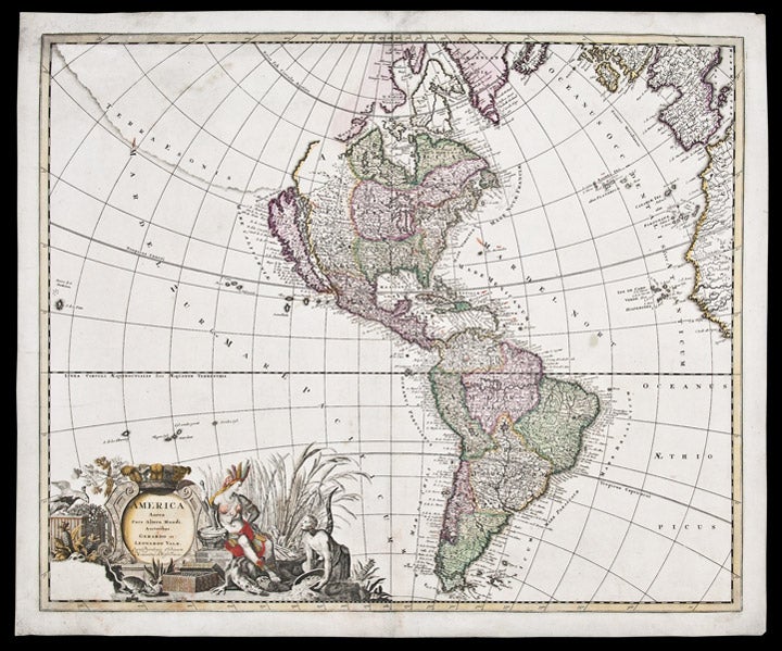

VALK, Gerard (c.1650-1726) & Leonard VALK (1675-1755)
America Aurea Pars Alter Mundi Auctoribus
Amsterdam: [circa 1700]. Copper-engraved map, full period hand-colouring. Sheet size: 21 1/8 x 25 1/4 inches.
Highly decorative map of North and South America showing California as an island and here with full period hand colouring.
This decorative map by the Valk brothers is after a similar map by Carol Allard, first published circa 1696. Cartographically, both Allard and the Valks borrow heavily from the De Wit map of 1675, naming the Great Lakes, showing California as an island and with a Terra Esonis and Fretum Anian in the northwest. Interestingly, the Valks here re-issue the first state of Allard's map, i.e. before the re-engraving of the western Great Lakes and the Mississippi River (based on Hennepin's mapping). In addition, the lower left corner of the cartouche is left blank, whereas in subsequent issues of the Allard map, an inset of New Zealand appears. In the present issue, there are no toponyms on Terra Esonis and the South Pacific is without New Guinea.
Cf. Burden, The Mapping of North America II: 724 (discussing the map under the entry for Allard); Wagner, Cartography of the Northwest Coast, 496; Tooley, "California as an Island," 68 in Tooley, The Mapping of America; McLaughlin,The Mapping of California as an Island, 176.
Item #25683
Price: $1,750.00