
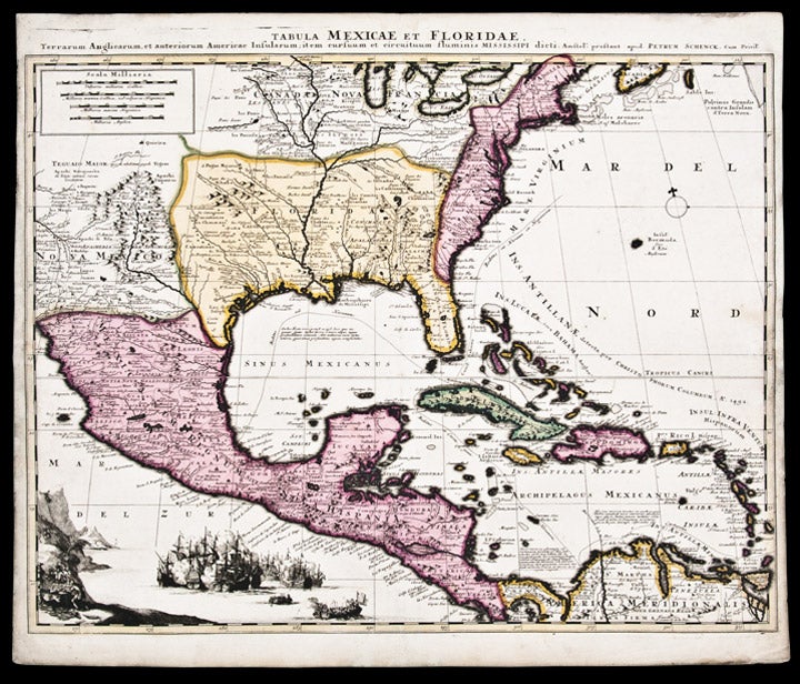
SCHENCK, Peter (1645-1715)
Tabula Mexicae et Floridae, Terrarum Anglicarum, et Anteriorum Americae Insularum; Ite, Cursuum et Circuituum Fluminis Mississippi Dicti
Amsterdam: [circa 1710]. Copper-engraved map, full period hand-colouring. Sheet size: 20 1/2 x 24 1/4 inches.
Highly decorative Dutch derivative of De l'Isle's monumental 1703 mapping: this copy a dark impression with beautiful full period colour.
Despite the title, this map covers a large portion of North America, from the Great Lakes in the north, through Texas and Mexico to Panama in the south, with Delisle's excellent depiction of the Mississippi River Valley. The Southwest shows missions and native villages, including Acoma, as well as Taos, Santa Fe, and Casas Grandes. The region that became Texas was then under French rule and part of "Florida" (later changed to "Louisiana"). Its southern border is the Rio Norte (Rio Grande) which winds back towards Taos. In East Texas, the Indian villages are designated where the Spanish constructed missions and presidios. Much of what became northTexas was then ruled and occupied by the Comanches, farther south and west in Nova Mexico, as the map notes, was "Apacheria or Terra Apachorum", region of the Apaches. Schenk has added a vignette off the Pacific coast of Central America, reflecting the wealth of the region with an elaborate sea battle between Spanish and French forces and a scene of buccaneers unloading a treasure chest. The route of the annual Spanish treasure fleet wind through the Gulf.
Martin & Martin, Maps of Texas and the Southwest p. 93 and plate 16; Wheat Mapping the Transmississippi West 107; Lowery 198.
Item #25713
Price: $1,800.00