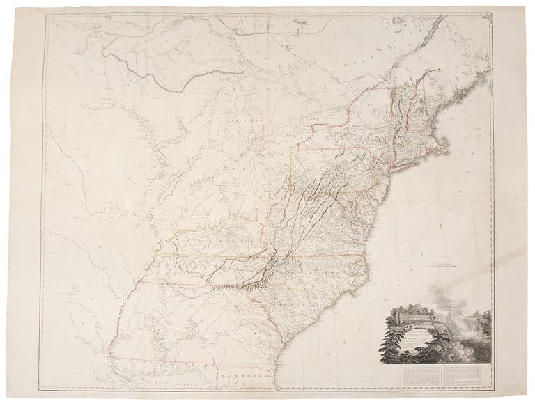

ARROWSMITH, Aaron (1750-1823)
A Map of the United States of North America Drawn from a number of Critical Researches...
London: 1802 [but, 1808]. Engraved map, on four sheets joined, period hand colouring in outline. Linen-backed. Sheet size: Approx. 50 x 58 1/2 inches.
Arrowsmith's famed wall map of the United States.
First published in 1796, the map was updated in 1802. Three issues of the 1802 are noted, this being the third, with Arrowsmith's address given as "10 Soho Square." This copy on paper watermarked 1808. Of this issue, Stevens and Tree note: "Many new place names and rivers added." Aaron Arrowsmith was the founder of one of the leading London map publishing houses in the early part of the nineteenth century. He came to London about 1770 from Durham, his birthplace, and worked as a surveyor for John Cary for whom he carried out some of the road surveys which subsequently appeared in Cary's Travellers' Companion in 1790. In that year he set up his own business in Long Acre and soon established an international reputation. "Aaron Arrowsmith, Hydrographer to the King of England and Geographer to the Prince of Wales, was the most influential and respected map publishers of the first quarter of the nineteenth century ... His role in cartographic production was to gather the best information available from a wide variety of sources, weigh the relative merits of conflicting data, and compile from this the most accurate depiction possible of an area. " (Martin & Martin, p. 113.) Starting in 1796, Arrowsmith steadily improved the present map, incorporating the latest town names and geographical discoveries as they were made available to him: the present issue, for instance, includes "many new place-names and rivers", and by the time that the final issue appeared (in 1819 or later) whole new Territories and States had been added. The sequence forming not only a demonstration of Arrowsmith's working methods, but also a kind of time-lapse snap-shot of the development of the young nation.
Stevens & Tree, "Comparative Cartography" 79e, in Tooley, The Mapping of America.
Item #25805
Price: $12,000.00