[CIVIL WAR] - LINDENKOHL, Adolph
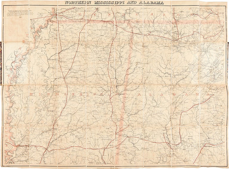
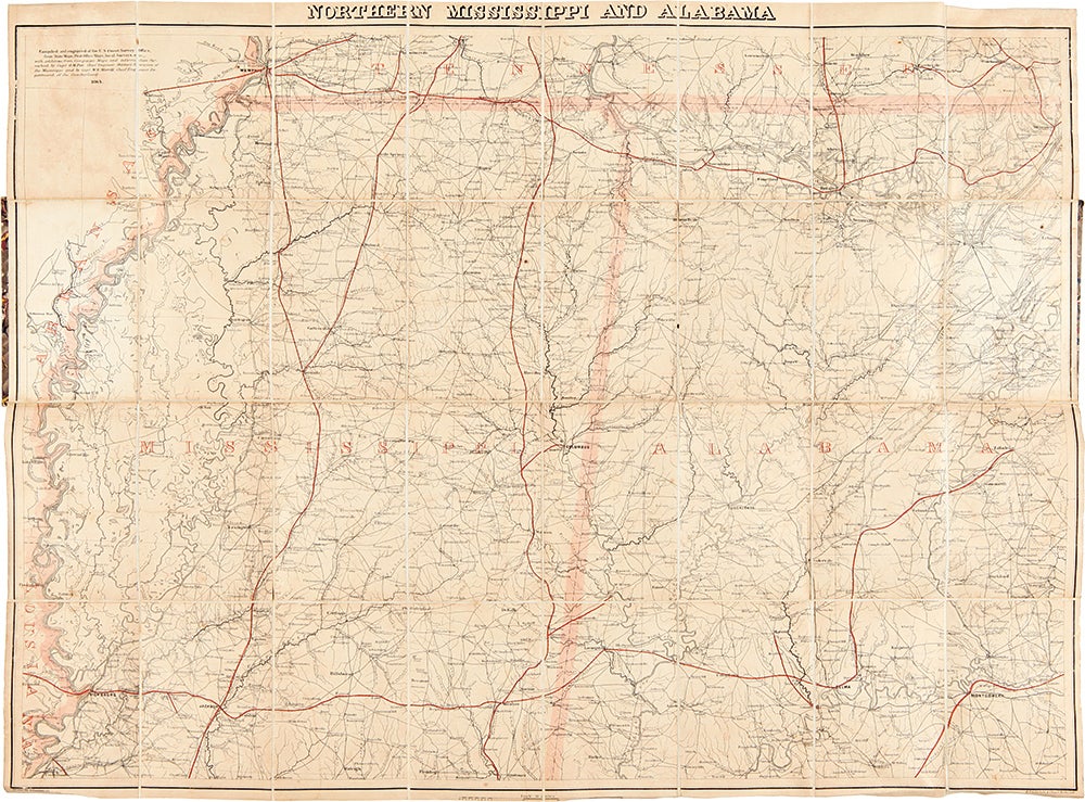
Northern Mississippi and Alabama
[Washington]: 1864. Folded map, 24 x 33 inches, in thirty-two segments mounted on linen. Original card covers with printed paper label. Contemporary ownership inscription on label. Some light wear and minor soiling.
Detailed field map for the Union Army in Northern Mississippi and Alabama.
A highly detailed map of the northern half of Mississippi and Alabama, showing the border with Tennessee and all points south to Vicksburg and Montgomery, produced to support the operations of the Union Army there in 1864. This is one of several maps compiled by the U.S. Coast Survey in an attempt to adequately map the South during the Civil War for military purposes. A note on the map indicates that the present map was compiled from various sources, including "campaign maps and information furnished by Capt. O.M. Poe, Chief Engineer, Military Division of the Mississippi, and by Capt. W.E. Merrell, Chief Engineer, Department of the Cumberland." Merrill was Sherman's chief topographical engineer, and he contributed to several important maps of the area, including one of Northern Georgia produced in Chattanooga following the vital capture of that city. With the beginning of the Civil War the United States Army found itself scrambling to obtain adequate field maps for military operations in the South. The most established cartographic branch of the Government, the Coast Survey, was pressed into service to provide these maps, some with a coastal component but mainly for landlocked locations. The cartographers of the Coast Survey reviewed all of the existing cartography available, but also drew on military and scouting reports and covert agents to assemble the most detailed possible maps of places, roads, railroads, natural features. The topography is illustrated with hachured and shaded relief, and railroads shown in red. The circulation of these maps was controlled, and only officers ranking major or higher were supposed to control copies. As a result, they are rare today. Two key figures in the Coast Survey effort during the War were Henry Lindenkohl and his brother Adolph, who were responsible for actually drawing many of the field maps. The Lindenkohls were born in Germany, but emigrated to the United States as teenagers and became American citizens. Adolph had already worked at the Coast Survey before the War began, and Henry joined in 1861. Together they made a huge contribution to the war effort through their superb cartographic work, producing and revising maps of different theatres of operations through 1865. Both continued with the survey for the rest of their lives; Adolph died in 1904 after fifty years on the job, and Henry in 1920 after fifty-nine. This map has the ownership inscription of Col. Joseph Corson Read (1831-1889). Read was one of the first wave of men to take up Abraham Lincoln's call for volunteers to put down the rebellion in April 1861. He remained continuously in the army, serving first on General Jesse Reno's staff and rising to the rank of Chief Commissary for the Army of the Cumberland, commanded by Gen. George H. Thomas. Thomas was impressed with Read, and on May 1, 1864, with the spring campaign against Atlanta imminent, Thomas named Read Chief Commissary of the Army of the Cumberland in the Field. This meant that, although Col. A.P. Porter was the Army's overall chief, Read would serve alongside Thomas in the field and had the responsibility to supply the entire army as it moved South. During the long and arduous Atlanta campaign he was the man on the ground, making the supply side work. Read developed a close relationship with Thomas, one with both personal and professional aspects. An important map of Northern Mississippi and Alabama, particularly interesting as part of the greater project undertaken by the Coast Survey to map out the South during the Civil War, and with excellent provenance and associations.
Item #27011
Price: $3,750.00