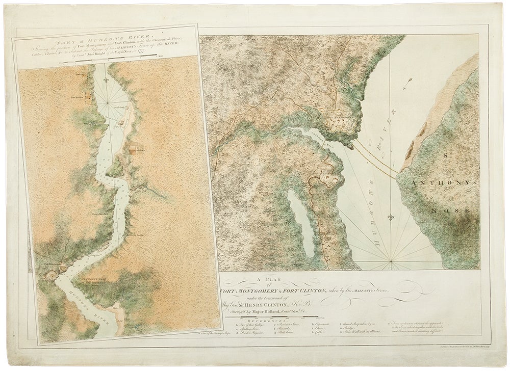
![Item #33200 A plan of Fort Montgomery and Fort Clinton, taken by His Majesty's forces, under the command of Maj. Gen.l Sir Henry Clinton, K.B: Survey'd by Major Holland, Surv.r Gen.l &c. ... [With large inset titled:] Part of Hudsons River, shewing the position of Fort Montgomery and Fort Clinton, with the Chevaux de Frieze, cables, chains, &c to obstruct the passage of his Majesty's forces up the river. By Lieut. John Knight of the Royal Navy in 1777. J. F. W. DES BARRES, publisher - Samuel HOLLAND, John KNIGHT.](https://donaldheald.cdn.bibliopolis.com/pictures/33200.jpg?width=768&height=1000&fit=bounds&auto=webp&v=1491932250)
DES BARRES, J. F. W. (1721-1824), publisher - Samuel HOLLAND (1728-1801) and John KNIGHT
A plan of Fort Montgomery and Fort Clinton, taken by His Majesty's forces, under the command of Maj. Gen.l Sir Henry Clinton, K.B: Survey'd by Major Holland, Surv.r Gen.l &c. ... [With large inset titled:] Part of Hudsons River, shewing the position of Fort Montgomery and Fort Clinton, with the Chevaux de Frieze, cables, chains, &c to obstruct the passage of his Majesty's forces up the river. By Lieut. John Knight of the Royal Navy in 1777
London: 1779. Engraved and aquatint map, period hand colouring. 14 lettered references, large inset with title as above.
Rare revolutionary chart of the Hudson River showing the American defenses, on the eve of the Battle of Fort Montgomery.
On October 6, 1777, a British force led by Lieutenant General Sir Henry Clinton attacked Forts Montgomery and Clinton from the landward side, where the American defenses were only partially completed. Support from cannon fire from British ships on the Hudson River that had passed through the chevaux de frise on the lower river. By the end of the day, both forts had fallen to the British, who burned the forts and tore down the stonework buildings. However, the battle was a pyrrhic victory for the British. The campaign against the forts caused delays in reinforcing General John Burgoyne at Saratoga, where Americans forced the British surrender ten days later at the Battle of Saratoga before Clinton's forces could arrive. The present map, which depicts the Forts and the River defenses prior to the battle, is from The Atlantic Neptune, the finest large scale sea atlas of the United States and Canadian Atlantic coastline ever produced. The maps in the atlas were produced over a seven-year period (1775-82), and are well known for their accurate portrayal of various sounds, bays, bars, harbors as well as navigational hazards. This atlas was used extensively by the Royal Navy during the American Revolution. Des Barres studied under the great mathematician Daniel Bernoulli at the University of Basel, before continuing on to the Royal Military College at Woolwich. On the outbreak of the Seven Years war in 1756, he joined the British Royal American Regiment as a military engineer. He came to the attention of General James Wolfe, who appointed him to be his aide-de-camp. From 1762, Des Barres was enlisted to survey the coastlines of Nova Scotia, Newfoundland, and the Gulf of St.Lawrence, while his colleague, Samuel Holland charted the New England coast and further south. In 1774, Des Barres returned to England where he began work on the Neptune. His dedication to the project was so strong, that often at his own expense, he continually updated and added new charts and views up until 1784. That year he returned to Canada, where he remained for a further forty years, becoming a senior political figure and a wealthy land owner, and living to the advanced age of 103. The Atlantic Neptune was the first British sea atlas of her North American colonies, and one of the most important achievements of eighteenth century cartography. With an official commission from the Royal Navy, Des Barres published the first volume in London in 1775, which was soon followed by further volumes. Des Barres' monumental endeavor eventually featured over two-hundred charts and aquatint views, many being found in several states. All of the charts were immensely detailed, featuring both hydrographical and topographical information. The Neptune met with the highest acclaim from the beginning, and is today widely regarded as superior to all other atlases produced during its time. Henry Stevens identified only a single state of this chart, issued coloured or uncoloured, which appeared in some examples volume four, part two of the Atlantic Nepture; the map, however, is not listed in the engraved list of maps for that section, and given the rarity was likely not issued in all copies.
National Maritime Museum: Henry Stevens Collection: HNS156; Cf. Phillips, Atlases 1198; Hornsby, Surveyors of Empire: Samuel Holland, J.F.W. Des Barres and the Making of the Atlantic Neptune (2011).
Item #33200
Price: $22,500.00