
LE MOYNE, Jacques (c.1533-1588), DE BRY, Theodor (1528-1598, Engraver)
Brevis Narratio eorum quae in Florida Americae Provicia Gallis acciderunt, secunda in illam Nauigatione, du ce Renato de Laudoniere classis Praefecto. Quae est seconda pars Americae
Frankfurt: Theodor De Bry Leodiense, 1591. Folio. (13 1/4 x 9 1/2 inches). *4 a-d4 A-G6 H-I5 K4. 76 ff. [8] 1-30 [4] [84] [26]. 152 pp. 47 engravings including the title, section title, folding map "Florida Americae Provinciae," and 42 plates after Le Moyne with letterpress titling and descriptive text, and 2 other illustrations. With woodcut initials and head and tailpieces. Title, Dedication, Preface, Privilege, Folding Map, Americanae Historiae Pars Secunda, Index Capitum, Section Title, Plates I-XLII, Supplicatoria, Gallorum, Index, Parergon, Colophon. Map with expert restoration, some leaves from second setting.
Expertly bound to style in contemporary full limp vellum with flat spine all edges stained red. Housed within a black clamshell
Seminal early American illustrated work, with Le Moyne's spectacular images of Native Americans and the "most important map of Florida." [Baxter]
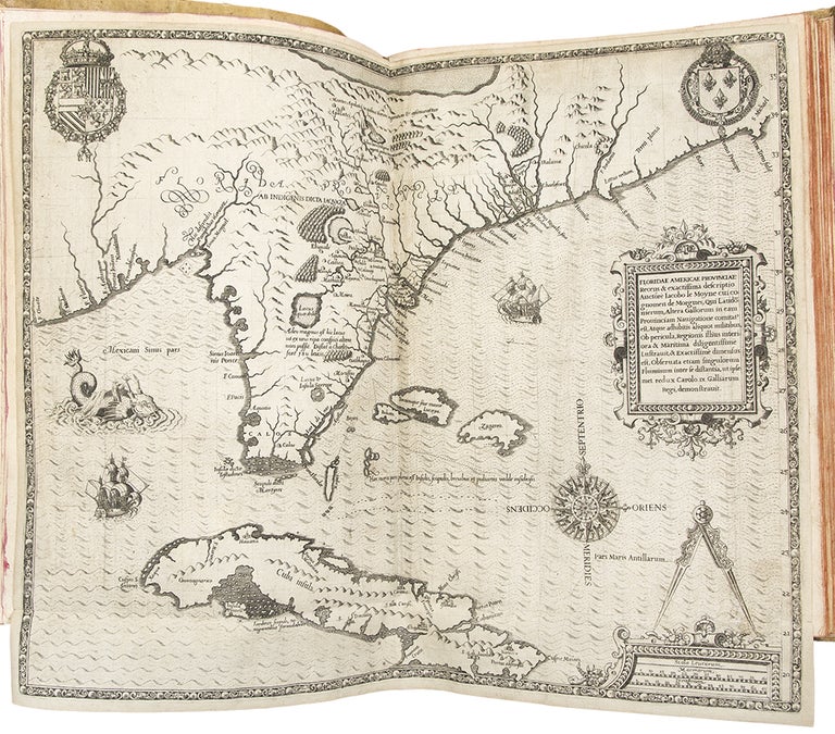
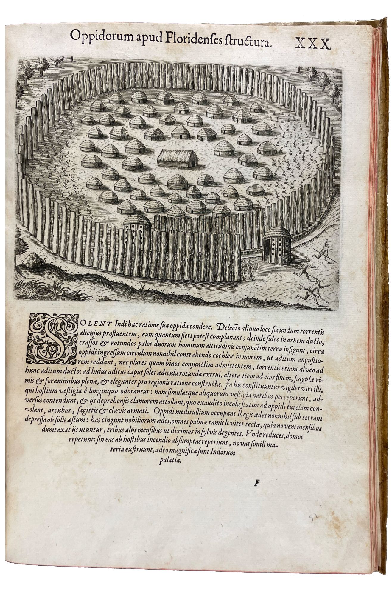
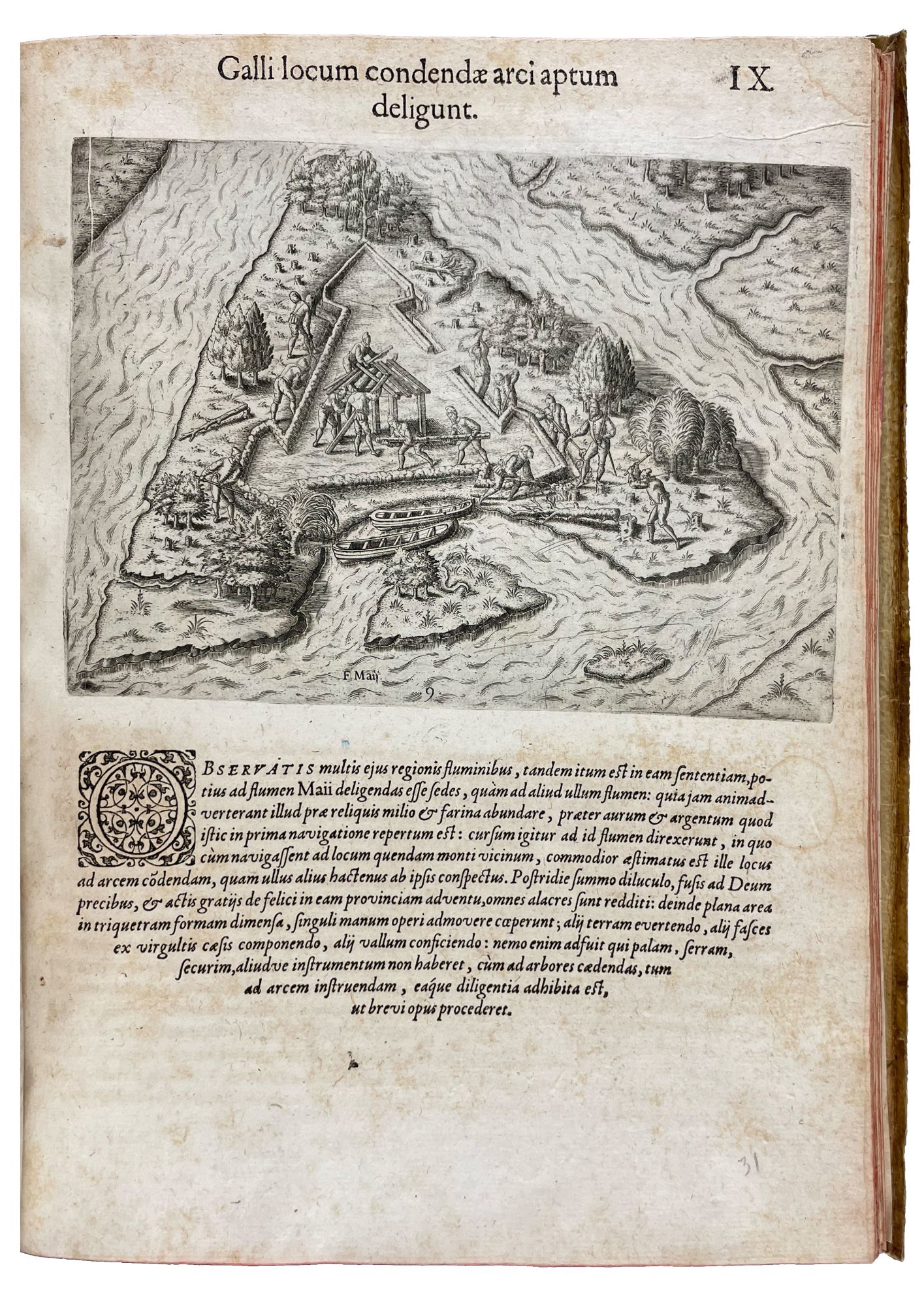
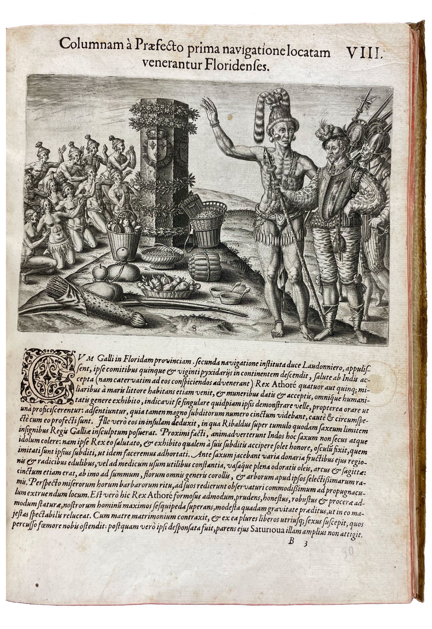
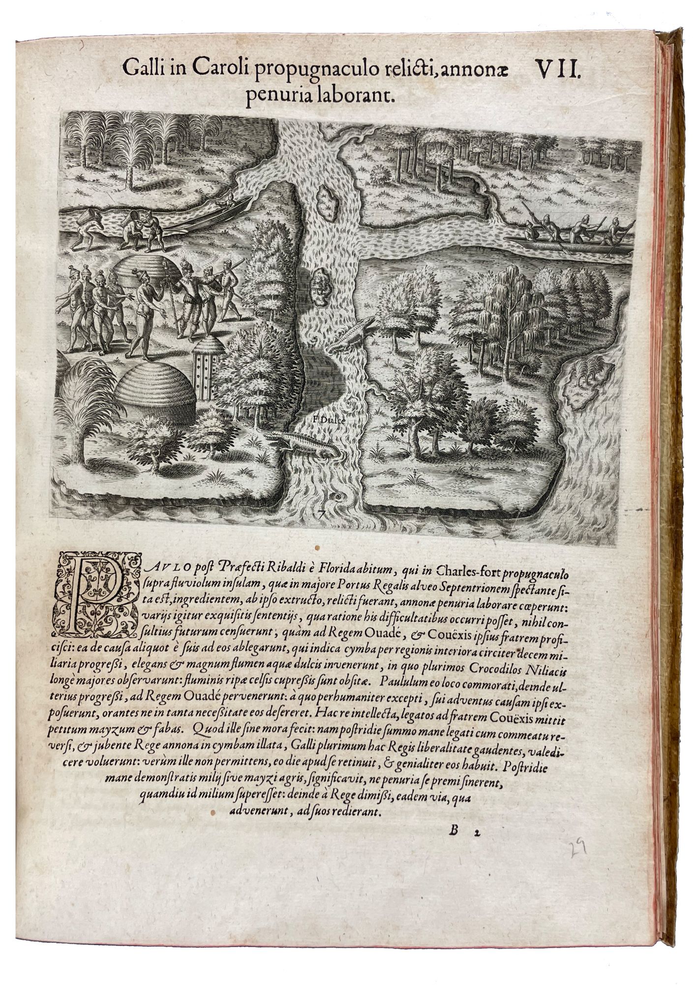
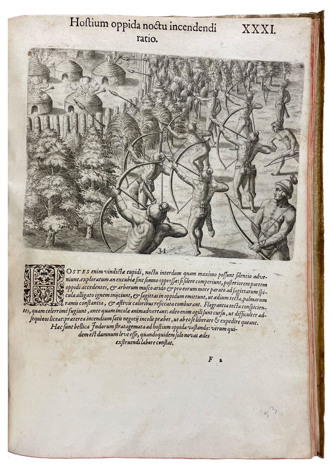
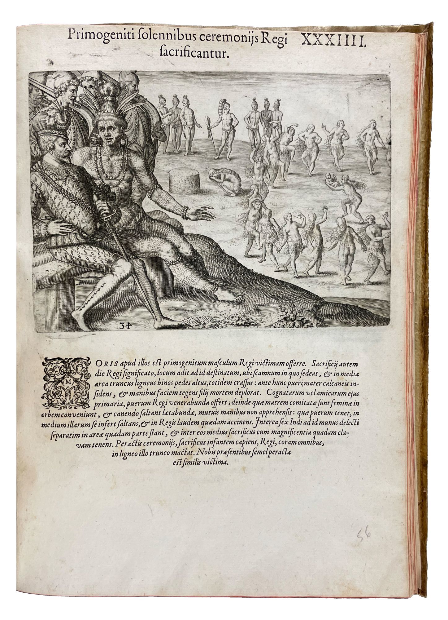
With the publication of this work, together with Hariot's Virginia, De Bry launched what would later become known as his Grand Voyages. These first two works are without question the most important of the series both in terms of their contemporary influence and their historical and ethnographic value to modern scholars and collectors. The text of the Brevis Narratio describes the earliest French settlements in what is now the United States and are here united by De Bry with engravings based on watercolors by a member of the expedition to the New World. To most of the Old World, this work presented the first accurate eyewitness depiction and account of Native Americans. In the mid-1560s, two French expeditions led by Jean Ribault (1520-1565) and René Goulaine de Laudonnière (1529-1574) sought to establish a Hugenot settlement in Florida. Among those accompanying Laudonnière was Jacques Le Moyne: born in Dieppe, France, in about 1533, he was appointed artist to the expedition, which sailed in April 1564. Arguably the first Western artist to visit the New World, Le Moyne recorded the scenery of Florida and the lives of the Timucua Indians in great detail, as well as charting the coastline of Florida and much of present-day South Carolina. Unfortunately, the nascent French colony was seen as a threat by the Spanish, the dominant European power in the region, and in September 1565, a force led by Pedro Menéndez (1519-1574) massacred the French colonists at Fort Caroline. Le Moyne and several others, however, made a miraculous escape. The story of their struggles was not published until 1588, when, at the instigation of Richard Hakluyt (1553-1616), Laudonnière's journal was published in Paris. Later that year, master engraver and publisher Theodor De Bry traveled to London, and met with Le Moyne in an unsuccessful attempt to obtain illustrations of the region to accompany a new edition of Laudonnière's journal. Following Le Moyne's death the following year, De Bry returned to London and purchased the watercolors from his widow. It was on this trip to London that De Bry met Hakluyt, who informed him of the British expeditions to Virginia, shared with him both Hariot's journal and White's watercolors from the expedition, and suggested the publication of a series of illustrated voyages to America, beginning with Hariot/White and Laudonnière/Le Moyne. De Bry returned to Frankfurt and in 1590 published the former in Latin, German, French, and English; the following year he published the latter in Latin and German. Le Moyne's extraordinary illustrations of the Florida Indians, which appear on forty-two leaves of this work in their first published form, rank with those of John White as the best visual record of American Indians before the 19th century. They show all aspects of Indian life, including settlements, ceremonies, wars, agriculture, hunting, and preparation of food. They also show scenes of the French settlement and their involvement with the Indians. These images were widely copied for centuries, and many later supposedly original illustrations of American Indians are actually copies of Le Moyne's illustrations. A full list of the plates appears in Church. The map, which appeared for the first time with this text, is one of the most elaborate of the Florida peninsula to appear in the 16th century, giving the names assigned by the French and Spanish. Cumming provides an elaborate description, and Baxter describes it as "the most remarkable and important map, which has been preserved from the sixteenth-century maps, of that part of the East Coast which lies between Cape Hatteras and Cape Florida, and the first French map to show Florida. It is considered the most important map of Florida."
Arents 39. Brunet I, 1320. Burden, Mapping of North America 79. Church 145. Cumming and De Vorsey 14. Clark I:16. European Americana 591/39. JCB (3) I:387-88. Sabin 8784. Schwartz and Ehrenberg, pp.64-67. Streeter sale II, 1172.
Item #34276
Price: $55,000.00