

FRY, Joshua (1700-1754), & Peter JEFFERSON (1708-1757)
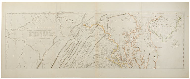
A Map of the most Inhabited part of Virginia containing the whole Province of Maryland with part of Pennsilvania, New Jersey and North Carolina
London: Printed for Robt. Sayer and Thomas Jefferys, 1775. Copper-engraving with period outline hand colouring. Printed on four folio sheets, joined into two, and measuring 30 ¾ x 48 ¾ inches if joined. 6th state of 8.
A landmark in the mapping of Virginia and Maryland.
This is the most important eighteenth century map of Virginia. It was the first to accurately depict the Blue Ridge, and to lay down the colonial road system of Virginia. A great number of plantations are located and identified by family name. The attractive cartouche depicts, appropriately, a tobacco warehouse and wharf, with a slave bringing one of the owners a drink, and is one of the earliest images of the Virginia tobacco trade. The map was commissioned by the English Lords of Trade, who in 1750 required each colony to conduct a comprehensive survey. Joshua Fry, a mathematician at the College of William and Mary, and Peter Jefferson, a surveyor and the father of Thomas Jefferson, who together had drawn the boundaries of Lord Fairfax's lands in 1746 and surveyed the Virginia-North Carolina boundary in 1749, were appointed to execute the commission. Completed in 1751, the map was a masterful synthesis of original surveys and existing data. A major revision in 1755 incorporated important information about the western part of the colony from the journals of John Dalrymple, surveys of Christopher Gist and other sources. It is the 1755 edition that forms the basis for the subsequent editions. While all English editions of the map are now rare, the first two referred to above are extremely so. Eight separate states of the Fry-Jefferson map have been identified. The four early states culminate in the issue of 1755, by which time all of the important geographical revisions were incorporated. In the four states subsequent to 1755, geographic detail was unchanged, but bibliographic detail (e.g. publisher's imprint) varied. The first four states are so rare as to be virtually unobtainable. The present example is state 6, as identified by Coolie Verner, which differs from state 5 only by the date printed in the title (1775 instead of 1751), and from state 7, by a change in imprint (state 7 omits Jefferys' address, which is included in state 6).
Degrees of Latitude, 30; Stephenson & McKee Virginia in Maps, Map II-21A-D, p. 83; Cumming 281; Coolie Verner, "The Fry and Jefferson Map", Imago Mundi XXI, pp. 70-94; cf. On the Map, Figure 42; Papenfuse & Coale, pp. 34-36.
Item #34384
Price: $22,500.00