
DES BARRES, J. F. W. (1721-1824)
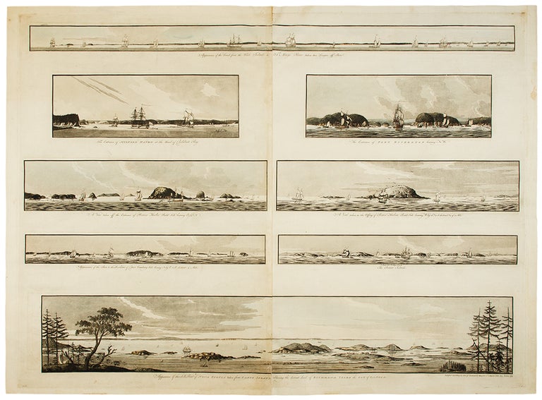
[8 Navigational Profiles near Nova Scotia}: Appearance of the Land from the White Islands to St. Marys River taken two Leagues off Shore; The Entrance of Milford Haven at the Head of Chedabucto Bay; The Entrance of Port Bickerton bearing N. W.; A View taken off the Entrance of Beaver Harbor Bald Isle bearing E, 150 N; A View taken in the Offing of Beaver Harbour Bald Isle bearing W. by S. 3/4 S. distant 3/4 of a Mile; Appearance of the Shore to the Westward of Canso Cranberry Isle bearing N. by E. 1/2 E. distant 4 Miles; C. Bald Isle bearing N. 1/2 E. The Beaver Isles; Appearance of the S. E. Point of Nove Scotia taken from Canso Island Shewing the distant Land of Richmond Isles the Gut of Canso &c.
London: J.F.W. Des Barres, 1781. Hand-colored line engraving and aquatint. Two plates printed on two sheets, joined with 8 views arranged in 5 rows. Sheet size: 32 x 43 3/4 inches.
8 navigational profile views from the greatest of all 18th century sea atlases.
These eight views of sites in and around Nova Scotia were designed to give navigators additional information to the soundings on the charts of these same places. Several of the placenames have changed, but Beaver Island, Port Bickerton, Chedabucto Bay and Canso remain. This is the 5th of 5 states with many ships and aquatinted features to the landscapes added to the original plates. Des Barres, of Swiss-Huguenot extraction, studied under the great mathematician Daniel Bernoulli at the University of Basel, before continuing on to the Royal Military College at Woolwich. Upon the outbreak of hostilities with France in 1756, he joined the British Royal American Regiment as a military engineer. He came to the attention of General James Wolfe, who appointed him to join his personal detail. During this period he also worked with the future legendary explorer James Cook on a monumental chart of the St. Lawrence River. From 1762, Des Barres was enlisted to survey the coastlines of Nova Scotia, Newfoundland, and the Gulf of St. Lawrence, while his colleague, Samuel Holland charted the New England coast. He also managed to gain access to some surveys of the American South, Cuba and Jamaica. In 1774, Des Barres returned to England where he began work on The Neptune. His dedication to the project was so strong, that often at his own expense, he continually updated and added new charts and views up until 1784. That year he returned to Canada, where he remained for a further forty years, becoming a senior political figure and a wealthy land owner, and living to the advanced age of 103.
The American Revolution in drawings and prints; a checklist of 1765-1790 graphics in the Library of Congress / Compiled by Donald H. Cresswell, with a foreword by Sinclair H. Hitchings. Washington : 1975, no. 397-404; #61e Henry Stevens Collection.
Item #34403
Price: $7,500.00