
CORONELLI, Vincenzo Maria (1650-1718) and Jean-Nicolas de TRALAGE (c.1640-1699)
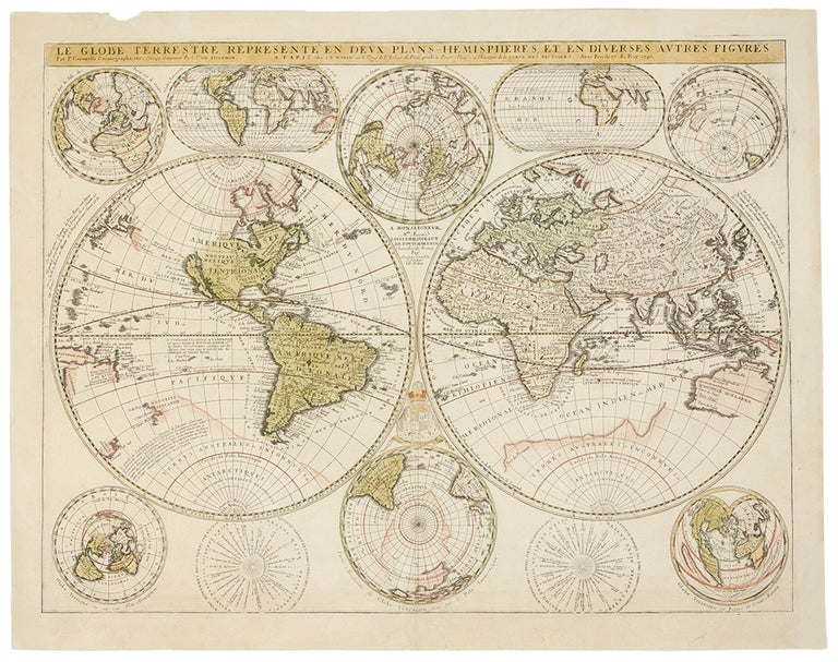
Le Globe Terrestre Representé En Deux Plans-Hemispheres Et En Diverses Autres Figures
Paris: Jean-Baptiste Nolin, [after 1690]. Copper-engraved map, with full contemporary color in many parts, outline color in others. Sheet size: 20 x 25 1/4 inches. Several expertly repaired tears.
A very beautiful and finely engraved world map, principally devised by one of the period's greatest cartographers.
This very fine map is the result of the synergy of the talents of Coronelli and his French colleague Tralage, popularly known as the Sieur de Tillemont. It principally depicts the world in a bi-hemispheric projection, and largely follows the geography represented on Coronelli's celebrated globe of 1688. California is shown to be an island, and in the enigmatic void that lies to the northwest is the 'Strait of Anian' that supposedly formed the western terminus of a Northwest Passage. Beyond the strait, just to the northeast of Japan is the mysterious "Terre de Jessu," perhaps representing Hokkaido. Much further south, the loosely-defined area that is now known as New Guinea is labelled as the "Terre de Quir," noting on the map that it was discovered in 1606 by the Spanish explorer Ferdinand de Quir. The only major addition here to Coronelli's established geography is the appearance of the Solomon Islands. Surrounding these principal hemispheres are eight diverse hemispheric projections of the world, evincing a playful fascination with mathematics and perspective that anticipated the Enlightenment of the next century. Adorning the two upper corners of the map are a pair of hemispheres capturing the world from an oblique perspective, one centered on Paris, and the other from its diametrically opposite position in the antipodes. Also, in the upper portion of the map, is a pair of hemispheres capturing the world in an ovoid projection, and resting in the spaces in between the two main hemispheres are a pair of projections depicting the world from a perspective centered at the poles. In the lower left corner, the entire world is captured on a projection centered at the North Pole. Most strikingly, in the lower right corner the world is captured in a cordiform, or heart-shaped projection, which since it was first devised during the Renaissance was considered an iconological symbol of various humanist values. Vincenzo Maria Coronelli, a Venetian scholar and Minorite Friar, became one of the most celebrated map and globe makers of his era. Throughout his industrious life he produced more than one-hundred terrestrial and celestial globes, several hundred maps, and a wealth of cartographic publications. In 1683, he completed the Marly Globes for Louis XIV, the largest and most magnificent globes ever made. In 1684 he founded the Academia Cosmografica degli Argonauti, the first geographical society, and was appointed Cosmographer of the Republic of Venice. The present map is the result of the lucrative partnership Coronelli formed in the late 1680s with the prominent Paris cartographer Jean-Baptiste Nolin, who printed editions of Coronelli's maps that flourished on the French market. Coronelli published two atlases, the Atlante Veneto (Venice, 1691) and the Isolario (1696-98), and compiled the first encyclopedia to be arranged alphabetically. This map was first printed in 1690, and the present map is in the second state, as indicated by its dedication which honors Louis Philippeaux de Ponchartrain, the French minister of Finance.
Shirley, The Mapping of the World, 546.
Item #34416
Price: $5,500.00