
SENEX, John (1678-1740)
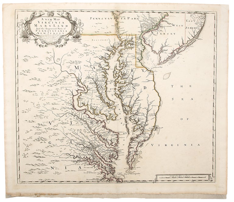
A New Map of Virginia Mary:Land and the Improved Parts of Pennsylvania & New Jersey
London: J. Senex, 1719 [ie 1721]. Copper-engraved map, with original outline colour. Sheet size: 20 1/8 x 22 7/8 inches.
A highly-important and finely-drafted map of Virginia, Maryland and Delaware by a great English cartographer.
This very elegant map is centered on Chesapeake Bay, and embraces all of the territory from Norfolk, Virginia up past Philadelphia in the north. Its antecedent was Augustine Herrman's 1673 manuscript map, which was first printed by Christopher Browne in 1685. Senex devised his own version of the map in 1719, and included it in his New General Atlas of 1721. The Browne map is extremely rare, making the present map the earliest reasonably obtainable example of this critical map. This map is one of the first of the subject to be oriented with the north on the top, and demonstrates that the geography of the region was by this time very well understood. The long-established provinces of Virginia and Maryland dominate the map, and in the north is the relatively new colony of Pennsylvania, founded by William Penn in 1681. Delaware is shown to be at this time still an appendage of Pennsylvania, known as the 'Lower Counties' of Penn's Grant. New Jersey is shown to be divided into East and West Jersey. An elegant Baroque title cartouche adorns the upper left corner.
Morrison On the Map 24; Stevens & Tree "Comparative Cartography" in TooleyThe Mapping of America 86(c); Stevenson & McKee Virginia in Maps p.78.
Item #34897
Price: $3,000.00