
DES BARRES, J. F. W. (1721-1824); after William PIERIE
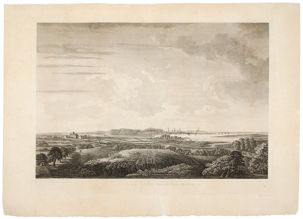
A View of Boston, Taken on the Road to Dorchester
London: J. F. W. Des Barres, 30 May 1776. Engraved view, printed on laid paper, engraved by James Newton after Pierie. Sheet size: 22 1/2 x 31 1/2 inches. First state.
Rare view of Boston from the road to Dorchester, published shortly after George Washington's first victory of the American Revolution.
Following the Battles of Lexington and Concord, American troops laid siege to Boston. Strategically, Dorchester Heights offered commanding views of both Boston town and harbour. On March 4, 1776, under the cover of darkness and with batteries firing from Roxbury and Cambridge to provide a diversion, George Washington moved canon captured at Ticonderoga onto the Heights and fortified the position. Faced with little choice given the overwhelming strategic advantage, General Howe retreated from Boston on March 17, giving George Washington and the Americans a decisive early victory in the war. The present view, accomplished by British artillery officer William Pierie in 1773, depicts Boston, Boston Harbor and Roxbury, as it would have been seen by Washington and the American army. The Shirley-Eustis house, the home of Governor William Shirley and later Governor William Eustis, in Roxbury is visible in the middle ground, and in the far distance the beacon is visible atop Beacon Hill. A rare view, published in 1776 in the New England section of Des Barres monumental Atlantic Neptune. Joseph Frederick Wallet Des Barres was born in Switzerland, where his Huguenot ancestors had fled following the repeal of the Edict of Nantes. He studied under the great mathematician Daniel Bernoulli at the University of Basel, before immigrating to Britain where he trained at the Royal Military College, Woolwich. Upon the outbreak of hostilities with France in 1756, he joined the British Royal American Regiment as a military engineer. He came to the attention of General James Wolfe, who appointed him to join his personal detail. Des Barres returned to London in 1774, where the Royal Navy charged him with the Herculean task of producing an atlas of sea charts of the American coast. The result was The Atlantic Neptune, which became the most celebrated sea atlas of its era, containing the first systematic survey of the east coast of North America. Des Barres's synergy of great empirical accuracy with the peerless artistic virtue of his aquatint views, created a work that "has been described as the most splendid collection of charts, plates and views ever published" (National Maritime Museum Catalogue). The Neptune eventually consisted of four volumes and Des Barres's dedication to the project was so strong that often at his own expense he continually updated and added new charts and views to various editions up until 1784, producing over 250 charts and views, many appearing in several variations. Following the completion of The Neptune, Des Barres returned to Canada, where he remained for a further forty years, becoming a senior political figure and a wealthy land owner, living to the advanced age of 103.
Henry Stevens Collection, HNS97; Deak 132.
Item #34921
Price: $15,000.00