
JEFFERYS, Thomas (1719-1771)
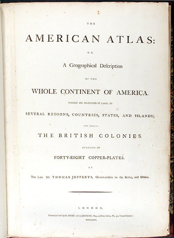
The American Atlas; or, a Geographical Description of the Whole Continent of America; Wherein are Delineated at Large its Several Regions, Countries, States, and Islands; and Chiefly the British Colonies
London: Printed and Sold by R. Sayer and J. Bennett, 1775. Folio. (21 1/4 x 15 1/8 inches). Mounted on guards throughout. Letterpress title and index leaf, otherwise engraved. 22 engraved maps, on 29 sheets (28 folding or double-page), all hand-colored in outline.
Expertly bound to style in eighteenth-century half Russia over contemporary marbled boards, the flat spine richly gilt in eight compartments divided by filets, Greek-key and rope-twist roll-tools, lettered in the second, the others with elaborate rococo repeat pattern.
"The American Atlas" is the most important 18th-century atlas for America. Ristow describes it as a "geographical description of the whole continent of America, as portrayed in the best available maps in the latter half of the eighteenth century. A major cartographic reference work it was, very likely, consulted by American, English, and French civilian administrators and military officers during the Revolution."
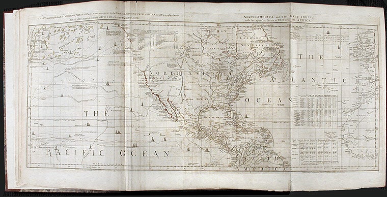
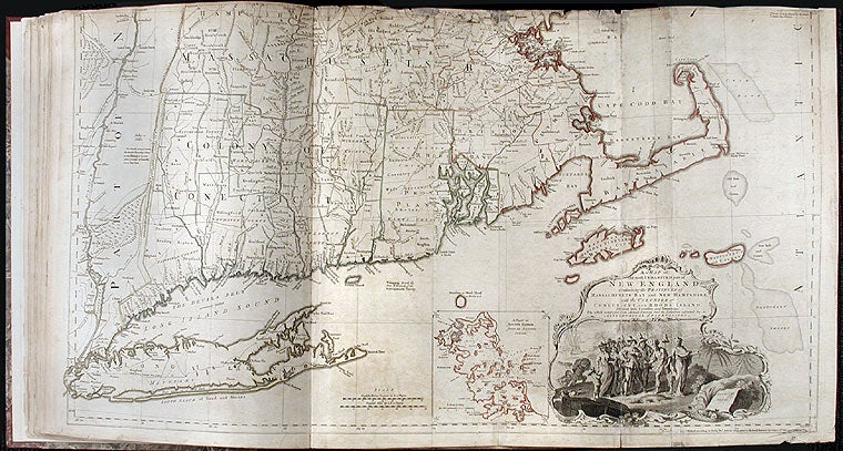
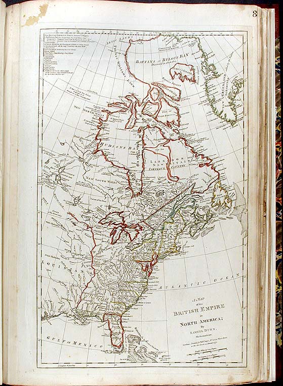
As a collection, the American Atlas stands as the most comprehensive, detailed and accurate survey of the American colonies at the beginning of the Revolution. Among the distinguished maps are; Braddock Meade's "A Map of the Most Inhabited Parts of New England," the largest and most detailed map of New England that had yet been published; a map of "The Provinces of New York and New Jersey" by Samuel Holland, the surveyor general for the northern American colonies; William Scull's "A Map of Pennsylvania," the first map of that colony to include its western frontier; Joshua Fry and Peter Jefferson's "A Map of the Most Inhabited Part of Virginia," the best colonial map for the Chesapeake region; and Lt. Ross's "Course of the Mississipi" the first map of that river based on English sources. Jefferys was the leading English cartographer of the 18th century. From about 1750, he published a series of maps of the English American colonies, that were among the most significant produced in the period. As Geographer to the Prince of Wales, and after 1761, Geographer to the King, Jefferys was well placed to have access to the best surveys conducted in America, and many of his maps held the status of "official work." Jefferys died on November 20th, 1771, and in 1775, his successors, Robert Sayer and John Bennett, gathered these separately-issued maps together and republished them in book form as The American Atlas. The maps are as follows. Many of the maps are on several sheets, and in the Index, each individual sheet is numbered, the measurements refer to the image sizes: 1. Braddock Meade (alias John Green). "A Chart of North and South America, including the Atlantic and Pacific Oceans." Published 10 June 1775. Six sheets joined into three, 43-1/2 x 49-1/2 inches. This great wall map was chiefly issued to expose the errors in Delisle and Buache's map of the Pacific Northwest, published in Paris in 1752. 2. Imperial Academy of St. Petersburg. "The Russian Discoveries." Published March 2nd, 1775. One sheet, 18 x 24 inches. 3. Bowen, E. and John Gibson. "An Accurate Map of North America." Published July 2nd, 1775. Four sheets joined into two, 43 x 47 inches. 4. Thomas Jefferys. "North America from the French of Mr. D'Anville, Improved with the English Surveys Made since the Peace." Published 10 June 1775. One sheet, 18 x 20 inches. 5. Samuel Dunn. "A Map of the British Empire in North America." Published 10 January 1774. 1/2 sheet, 12 x 19 inches. 6. Thomas Jefferys. "An Exact Chart of the River St. Laurence from Fort Frontenac to the Island of Anticosti." Published 25 May 1775. Two sheets joined into one, 23 1/2 x 37 inches. 7. Sayer and Bennett. "A Chart of the Gulf of St. Laurence . . ." Published 25th March 1775. One sheet, 19-1/2 x 24 inches. 8. "A Map of the Island of St. John in the Gulf of St. Laurence." Published 6 April 1775. One sheet, 15 x 27 1/4 inches. 9. James Cook and Michael Lane. "A General Chart of the Island of Newfoundland." Published May 10th, 1775. One sheet, 21 1/2 x 22 inches. James Cook went on to gain reknown for his Pacific exploration. 10. "A Chart of the Banks of Newfoundland." Published 25 March 1775. One sheet, 19-1/2 x 26 inches. Based on the surveys of James Cook, Chabert, and Fleurieu. 11. Braddock Meade (alias John Green.) "A New Map of Nova Scotia and Cape Breton Island with the Adjacent Parts of New England and Canada." Published June 15, 1775. One sheet, 18 1/2 x 24 inches. Originally published in 1755, at the beginning of the French and Indian War, this map "proved to be important in evaluating respective French and English claims to this part of North America." [Ristow] England gained sole possession of the region by the Treaty of Paris, 1763. 12. Braddock Meade (alias John Green.) "A Map of the Most Inhabited Part of New England." Published November 29, 1774. Four sheets joined into two, 38 3/4 x 40 ¾ inches. The first large-scale map of New England. "The most detailed and informative pre-Revolutionary map of New England. Not really supplanted until the nineteenth century." [New England Prospect] 13. Capt. [Samuel] Holland. The Provinces of New York and New Jersey, with Part of Pensilvania.... Published 16 June 1775. Three insets: A plan of the City of New York, A chart of the Mouth of Hudson's River, and A Plan of Amboy. Two sheets joined, 26 1/2 x 52 ¾ inches. * An important large-scale map of the Provinces of New York and New Jersey, by Samuel Holland, Surveyor General for the Northern English colonies. With fine insets including a street plan of colonial New York City. 14. Thomas Jefferys. The Middle British Colonies, viz. Virginia, Maryland, Delaware, and Pennsylvania, with the adjacent Colonies of New Jersey, New -York, Connecticut and Rhode Island...15June 1775. 15. William Scull. A Map of Pennsylvania Exhibiting not only the Improved Parts of the Province but also its Extensive Frontiers. Published 10 June 1775. Two sheets joined, 27 x 51 ½ inches. * The first map of the Province of Pennsylvania to include its western frontier. All earlier maps had focused solely on the settled eastern parts of the colony. 16. Joshua Fry & Peter Jefferson. A Map of the Most Inhabited Part of Virginia, containing the Whole Province of Maryland ... 1775. [n.d.] Four sheets joined into two, 32 x 48 inches. * "The basic cartographical document of Virginia in the eighteenth century ... the first to depict accurately the interior regions of Virginia beyond the Tidewater. [It] dominated the cartographical representation of Virginia until the nineteenth century" (Verner.) 17. Henry Mouzon. An Accurate Map of North and South Carolina with their Indian Frontiers. Published May 30, 1775. Four sheets joined into two, 40 x 54 inches. (First sheet [numbered 23], second sheet [numbered 24]). * "The chief type map for [the Carolinas] during the forty or fifty years following its publication. It was used by both British and American forces during the Revolutionary War" (Cumming, 450.) 18. Thomas Jefferys. The Coast of West Florida and Loisiana ... The Peninsula and Gulf of Florida. Published 20 Feby. 1775. Two sheets joined into one, 19 1/2 x 48 inches. * A large-scale map of Florida, based upon the extensive surveys conducted since the region became an English possession by the Treaty of Paris (1763). 19. Lt. Ross. Course of the Mississipi.... Taken on an Expedition to the Illinois, in the latter end of the Year 1765. Published 1 June 1775. Two sheet joined into one, 14 x 44 inches. * The first large-scale map of the Mississippi River, and the first based in whole or part upon English surveys. 20. Thomas Jefferys. The Bay of Honduras. Published 20 February 1775. One sheet, 18 1/2 x 24 1/2 inches. 21. J.B.B. D'Anville. A Map of South America.... Published 20 September 1775. Four sheets joined into two, 20 x 46 inches 22. Cruz Cano [etc.]. A Chart of the Straits of Magellan. Published 1 July 1775. One sheet, 20-1/2 x 27 inches
Howes J-81. New England Prospect 13. Phillips Atlases 1165. Ristow, Thomas JefferysThe American Atlas facsimile edition, passim. Sabin 35953. Streeter Sale I, 72.
Item #40437
Price: $100,000.00