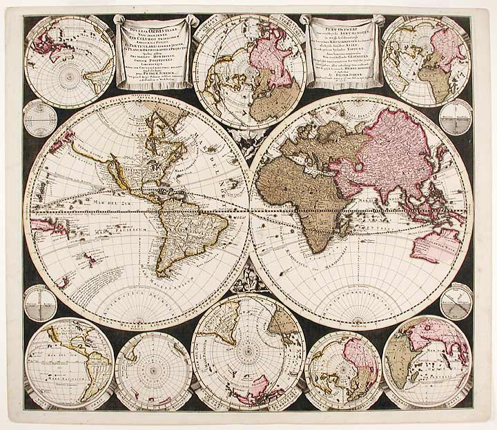

SCHENK, Peter (1645-1715)
Diversa Orbis Terræ. visu incedente per coluros tropicorum, ambos ejus polos, et particularis sphæræ zenith, in planum orthographica projectio... Plat Ontwerp van verscheyde Aert-klooten
Amsterdam: Peter Schenk, 1706. Copper-engraved map, with full original colour, in very good condition apart from one small expertly repaired tear to the old central fold, and two small repaired tears to coastlines. Sheet size: 21 1/8 x 24 11/16 inches.
A significant milestone in the history of cartography between the highly decorated 17th century Dutch style and the more 'rational' style of cartography of the mid-18th century.
Peter Schenk was a very prolific Amsterdam mapmaker working in the great Dutch cartographical tradition. Schenk's spectacular map is based on Carel Allard's map of 1696 (Shirley, 578). Shirley's description of the Allard image is equally relevant to the present example: 'The traditional decorative border of many seventeenth-century world maps has disappeared, and ... [the] twin central hemispheres are surrounded by eight smaller projections depicting the world from various angles, and four smaller circular diagrams. The dark cross-hatched background provides a striking contrast.' This map represents a radical departure from what had become a traditional format in Dutch 17th-century maps where the margins would be full of classical mythological figures and references. Here we have a more strictly scientific approach with only a handful of cherubs parceled in between the two largest hemispheres.
Cf. Koeman, Atlantes Neerlandici III, p. 119 no. 6; cf. Shirley, The Mapping of the World, 578.
Item #8184
Price: $4,500.00