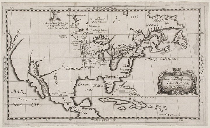

[JOLLIET, Louis] [HENNEPIN, Louis]
Tabula Exhibens Novam Franciam et Louisianam
[Nuremberg: 1689]. Engraved map, 7 3/4 x 12 3/4 inches. Near fine. Matted and laid into a black cloth box, with black morocco lettering piece.
An extremely rare German edition of Father Louis Hennepin's landmark map of North America, from his Description de la Louisiane..., based upon the explorations of Louis Jolliet and Father Jacques Marquette.
This version of the map was issued with the 1689 Nuremberg edition of Hennepin's work, and the cartouche translated from French into Latin. As in the original, the German map shows the significant new details of the upper headwaters of the Mississippi. By removing the extraneous European continent, the German map focuses solely on North America and even tends to magnify the Great Lakes region. This map drew directly on the explorations of the French fur trader Jolliet and the Jesuit Marquette. In May, 1673, the two led an expedition from Green Bay westward via the Fox and Wisconsin Rivers to find the upper Mississippi. Once they reached it, they travelled south past the Missouri, Ohio and Arkansas Rivers before turning back near present-day Natchez. On their return, they used the Chicago and Des Plaines Rivers to emerge on Lake Michigan at present-day Chicago. The information gathered by the explorers is the basis for the present map rendered by Hennepin. Hennepin's map is the first to use the name Louisiana, and the Atlantic Ocean is called Mare Canadense. "[It shows] for the first time La Louisiane, Sault de St. Antoine de Padou (on the site of present-day Minneapolis), and Lac de Pleurs [Lake of Tears], present Lake Pepin. A faint dotted line indicating the surmised course of the lower Mississippi River is approximately located" (Schwartz & Ehrenberg). This line is of particular note. As Wheat points out, La Salle and later French cartographers recorded the course of the river as progressing further west, making Hennepin's map remarkably accurate in this regard for its time. As a significant version of one of the best cartographical depictions to that date of the Great Lakes region and the upper Mississippi, it is surprising that this German edition of Hennepin's map has been overlooked by most carto-bibliographers. "An important cartographic stepping stone...[presenting] vast new knowledge" (Wheat).
(For the 1683 edition of the map): Schwartz & Ehrenberg, p.130; Wheat 62. (For the 1689 text and map): European Americana 689/94; Howes H415; JCB (4):207; Harrisse (NF) 163; Sabin 31364.
Item #8671
Price: $18,500.00