Maps
Results 1 - 22
(of 22)

CLARK, Matthew (1714-1798)
Chart of the Coast of America from C. Eliz to... - Item 37680
Price: $50,000.00![Item #40517 Chart of the Coast of America From [Ge]orge's Bank to Rhode Island including...](https://donaldheald.cdn.bibliopolis.com/pictures/40517-1.jpg?width=320&height=427&fit=bounds&auto=webp&v=1758810908)
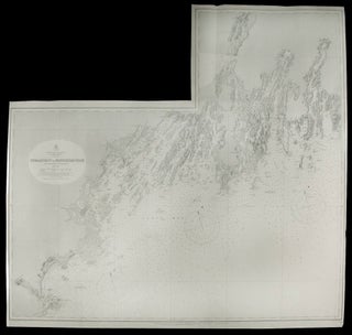
CLARK, Matthew (1714-1798)
Chart of the Coast of America From [Ge]orge's Bank to... - Item 40517
Price: $85,000.00![Item #34405 [Untitled chart of Boston Bay]. J. F. W. SAMUEL HOLLAND DES BARRES, publisher, and](https://donaldheald.cdn.bibliopolis.com/pictures/34405.jpg?width=320&height=427&fit=bounds&auto=webp&v=1581108978)
DES BARRES, J. F. W. (publisher) [and] SAMUEL HOLLAND
[Untitled chart of Boston Bay] - Item 34405
Price: $7,500.00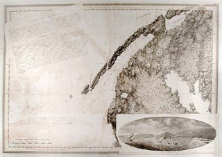
![Item #26675 [Chart of the Coast of Georgia]. J. F W. DES BARRES](https://donaldheald.cdn.bibliopolis.com/pictures/26675.jpg?width=320&height=427&fit=bounds&auto=webp&v=1366916316)
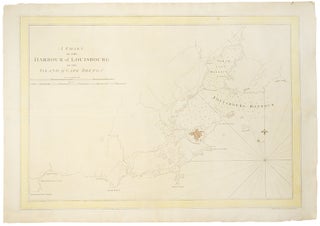
DES BARRES, J.F.W. (1721-1824)
A Chart of the Harbour of Louisbourg in the Island... - Item 19326
Price: $4,500.00![Item #5597 Egmont Harbour [modern Jeddore Harbour, Nova Scotia]. J. F W. DES BARRES](https://donaldheald.cdn.bibliopolis.com/pictures/05597-1.jpg?width=320&height=427&fit=bounds&auto=webp&v=1285274892)
DES BARRES, J.F.W. (1721-1824)
Egmont Harbour [modern Jeddore Harbour, Nova Scotia] - Item 5597
Price: $2,500.00![Item #28787 North East Coast of Nova Scotia / Northumberland Streights [sic] (One sheet). J. F W....](https://donaldheald.cdn.bibliopolis.com/pictures/28787.jpg?width=320&height=427&fit=bounds&auto=webp&v=1505334633)
DES BARRES, J.F.W. (1721-1824)
North East Coast of Nova Scotia / Northumberland Streights [sic]... - Item 28787
Price: $2,500.00![Item #34986 [Miramichi Bay]. Joseph F. Wallet DES BARRES](https://donaldheald.cdn.bibliopolis.com/pictures/34986.jpg?width=320&height=427&fit=bounds&auto=webp&v=1518730429)
![Item #33412 [Buzzards Bay and Vineyard Sound.]. JOSEPH FREDERICK WALLET DES BARRES, SAMUEL HOLLAND](https://donaldheald.cdn.bibliopolis.com/pictures/33412.jpg?width=320&height=427&fit=bounds&auto=webp&v=1491932250)
DES BARRES, JOSEPH FREDERICK WALLET (1721-1824) and SAMUEL HOLLAND
[Buzzards Bay and Vineyard Sound.] - Item 33412
Price: $28,500.00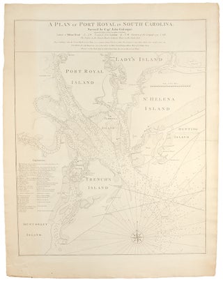
GASCOIGNE, John & William FADEN (1750-1836)
A Plan of Port Royal in South Carolina. Survey'd by... - Item 19684
Price: $4,000.00
GOOS, Pieter
Pas caerte van Nieu Nederlandt en de Engelsche Virginies van... - Item 20764
Price: $7,000.00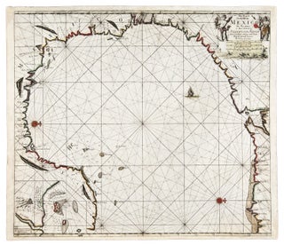
KEULEN, Johannes van (1654-1715) and Claes Janszoon VOOGHT (d. 1696)...
Pas-kaart van de Golff van Mexico - Item 25772
Price: $5,750.00![Item #10330 [Denmark] Carte de Detroit du Sond Contenant les Costes de L'Isle de Zélande...](https://donaldheald.cdn.bibliopolis.com/pictures/10330.jpg?width=320&height=427&fit=bounds&auto=webp&v=1380222228)
MORTIER, Pierre (1661-1711)
[Denmark] Carte de Detroit du Sond Contenant les Costes de... - Item 10330
Price: $1,250.00
[NORMAN, John]. - William NORMAN.
A New and Accurate Chart of the Bay of Chesapeak... - Item 23677
Price: $95,000.00![Item #13984 [English Channel] Canalis inter Angliæ et Galliæ Littora. Pasecaert van 't Canaal...](https://donaldheald.cdn.bibliopolis.com/pictures/13984.jpg?width=320&height=427&fit=bounds&auto=webp&v=1055884098)
RENARD, Louis (1678-1746)
[English Channel] Canalis inter Angliæ et Galliæ Littora. Pasecaert van... - Item 13984
Price: $1,000.00
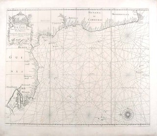
THORNTON, John (1641-1708) & Samuel (fl.1703-39)
A Chart of the Coast of Guinea from Cape de... - Item 19526
Price: $650.00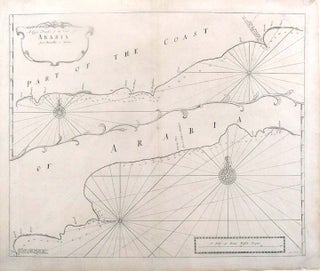
THORNTON, John (1641-1708) & Samuel (fl.1703-39)
A Large Draught of the Coast of Arabia from Maculla... - Item 19527
Price: $750.00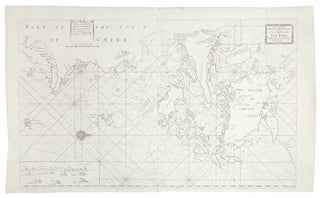
THORNTON, John (1641-1708) & Samuel (fl.1703-39)
A Large Draught of the North Part of China Shewing... - Item 19538
Price: $750.00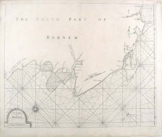
THORNTON, John (1641-1708) & Samuel (fl.1703-39)
A Large Draught of the South Part of Borneo - Item 19536
Price: $450.00Results 1 - 22 (of 22)